The England Cycling Data project aims to incorporate open data on cycling infrastructure released by the UK’s Department for Transport into OpenStreetMap.
We’ve started taking account of a greater range of information about cycle routes in OpenStreetMap (the project from which our routing is created). In particular, taking account of surface quality, barriers, traffic calming, and lighting in the routing, and have been continuing to develop this.
Earlier this year the DfT made available cycling data for England collected from surveying they undertook over the last few years. This has been converted to an OpenStreetMap-compatible format so that volunteers in the OSM community in each area can merge it in. The OS Open Data -based geometry has been ‘snapped’ to OSM geometries with intelligent matching of paths, and the metadata has been converted to using the OSM tagging system. This became available in June.
The conversion work has been undertaken by CycleCity Guides, who also did the original professional surveying for the DfT. The conversion work they have undertaken has been first-rate, and we’ve been impressed by the diligence taken, and accuracy of, the conversion process. We were particularly impressed by the skills of CCG’s GIS expert, Ralph Hughes. They seemed comfortable working with OpenStreetMap data and open data more generally as part of this process. We can certainly recommend CCG if you need professional surveying or data conversion work doing.
What’s in the data?
The data, licensed under the Open Government License, includes information on:
- The National Cycle Network (Sustrans NCN), though this is generally already in OSM
- Local Authority routes (again much of which is in OSM already, but this is a useful comparator), which helps us route cyclists over signed routes where practicable
- Surface quality (which helps us avoid muddy bridleways)
- The presence of traffic calming
- Cycle lane widths (which means that we distinguish between a useful, wide cycle lane, and one which is much less useful to cyclists)
- Whether a path is lit
The challenge now is to merge as much of this into OpenStreetMap as possible.
Andy Allan, one of the creators of the widely-used Potlatch 2 editor for OpenStreetMap, has created a new merging tool for OpenStreetMap. This was beta-tested earlier this year, and recent discussions on the OSM talk-gb mailing list have helped us identify some further improvements that will help assist the merging process.
How to merge in the data

We’ve created a screencast, which you can view below. But in summary, the merging process works as follows:
- Go to a Potlatch2 installation that has the data loaded
- Click ‘Map style’ > ‘Wireframe’ to make things much easier to work with.
- The background data is highlighted either orange (needs attention) or blue (already processed).
- Click a background feature to select it.
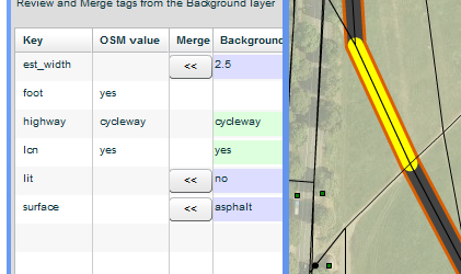
- Ctrl+click (or cmd+click on a Mac keyboard) the relevant OSM feature to see a side-by-side comparison of the tags.
- You can now review the tags, copy whichever ones are relevant
- Mark the background features as complete if there’s no more information to reconcile.
It takes about a day and a half to do a city the size of Cambridge (which has a lot of cycle infrastructure). Naturally, it does require local recognition of the area, but is a satisfying process.
What’s next?
We know that trying to get large areas of England in is a big task, and it will be interesting to see how the OSM community finds this in practice. So we’d welcome any feedback on your experiences with this data.
We’ve discussed with Andy Allan the remaining fixes needed to the merging tool, and have reserved funding for this. Clearly, we want to ensure this large task is made as easy as possible.
Shaun McDonald of ITO World has been working on some visualisations which we hope to report further on soon.
We’ve secured and written some articles for various widely-circulated cycling campaign magazines/newsletters, which we hope will raise awareness of OSM and introduce people to this data, as projects they could get involved in.
2 thoughts to “England Cycling Data project”
Thank you for this great project.
I’ve a number of bikes, but what I’d really like to see is options to route onto quieter (but not necessarily slow) roads. Sustrans routes can be excellent but are often no good at all for a road bike!
On the other hand, I don’t want to be routed onto a by-pass, which happen with some other map engines…..
Cheers
This is brilliant! Thanks for making it so easy. I have already discovered a discrepancy between where the DFT reckons an NCN route is and where both OSM and Sustrans reckon it is. I will investigate further. I suspect the DFT survey was done when the signage was still quite poor on the NCN route, and it was not clear where the route went.
However, I do think we should be encouraging everyone to record the source, either on the objects or the changeset when merging this data (or indeed any other data from a third party).